We are in the process of migrating all NASA Earth science data sites into Earthdata from now until end of 2026. Not all NASA Earth science data and resources will appear here until then. Thank you for your patience as we make this transition.
Read about the Web Unification Project
LP DAAC Learning Resources
Explore webinars, trainings, tutorials, and other learning resources from NASA’s Land Processes Distributed Active Archive Center (LP DAAC). Learn how to discover, access, process, and apply Earth science data from platforms and instruments such as MODIS, ASTER, VIIRS, GEDI, ECOSTRESS, EMIT, and HLS.
LP DAAC maintains a collection of dataset and topic-specific GitHub repositories that include step-by-step tutorials, scripts, guides, and example workflows for getting started with LP DAAC data. Users can browse available resources in the LP DAAC Data Resources GitHub repository, which serves as a central hub and provides links to additional LP DAAC–maintained GitHub repositories for specific datasets and topics.
Filters
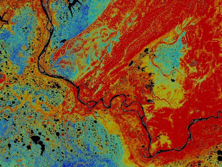
Discover how Landsat data were used map areas of the Alaskan Yukon River basin proving that land cover type was a good predictor of permafrost.
Data in Action
Dec. 10, 2014

Explore how LP DAAC data was used to forecast spring wheat yields in Canada, track elevation change at a U.S. coal mine, and examine land cover impacts on urban heat in Phoenix, Arizona.
Data in Action
Nov. 25, 2014

Learn how remote sensing data from space was used to detect and monitor the King Fire in California, showcasing the importance of satellite imagery in wildfire management.
Data in Action
Nov. 7, 2014

Explore how MODIS data supports research on tick-borne disease spread in Kansas, water stress in African rangelands, and long-term greenness trends in Alaska’s boreal ecosystems.
Data in Action
Oct. 28, 2014

Read highlights from the Spring/Summer 20214 term of NASA's DEVELOP program.
Data in Action
Oct. 21, 2014

ASTER data are used to evaluate the affects of Hurricane Ivan, a unique and destructive storm, after making two U.S. landfalls.
Data in Action
Sept. 30, 2014

See how digital elevation models are used to create three-dimensional data visualizations, which provide an insightful perspective on landscapes.
Data in Action
Aug. 18, 2014

Satellite data derived from ASTER imagery help tea growers in India assess crop health.
Data in Action
Aug. 14, 2014
SHOWING 8 OF 226