We are in the process of migrating all NASA Earth science data sites into Earthdata from now until end of 2026. Not all NASA Earth science data and resources will appear here until then. Thank you for your patience as we make this transition.
Read about the Web Unification Project
Terra Resources
Terra Documents
| Name Sort descending | Description | File Type | Date Published | |
|---|---|---|---|---|
| MODIS Terra/Aqua | MODIS Terra/Aqua | PDF (155.7 kb) | April 19, 2004 | |
| Multi-angle Imaging SpectroRadiometer (MISR) Overview | PDF (149.95 kb) | Feb. 24, 2021 | ||
| NASA Support for MODIS Direct Broadcast:Level-0 to Standard Ocean Products (PDF) | NASA Support for MODIS Direct Broadcast:Level-0 to Standard Ocean Products (PDF) | PDF (4.3 mb) | Oct. 3, 2005 | |
| NASA Support for MODIS Direct Broadcast:Level-0 to Standard Ocean Products (PPT) | NASA Support for MODIS Direct Broadcast:Level-0 to Standard Ocean Products (PPT) | PPT (4.62 mb) | Jan. 21, 2005 | |
| NASA/TM–2003–206892, Vol. 27 | NASA/TM–2003–206892, Vol. 27 | PDF (1.71 mb) | Oct. 14, 2003 | |
| observing_concept | Diagram showing terra space craft and misr observing concept. | PDF (241.22 kb) | May 22, 2005 | |
| Overview of MISR Data at the ASDC | General overview of MISR data hosted at the ASDC, including description of data products, and display and visualization tools. | PDF (227.41 kb) | Aug. 9, 2024 | |
| release_desc_l2as_v2.1.4.pdf | Algorithm changes, bug fixes, aerosol product changes, and science config file changes for level 2 misr aerosol | PDF (514.87 kb) | Sept. 27, 2001 | |
| Statement Concerning Quality of the MISR Ancillary Geographic Product September 19, 2000 | Here is a description of the **Statement_Quality_MISR_Ancillary_Geographic_09192000.pdf** document: This document is a Quality Statement for the MISR Ancillary Geographic Product (AGP), dated September 19, 2000, covering version F01_24. The AGP is a set of 233 pre-computed static files—one per Terra orbital path—that provide essential geographical data used as input by MISR production software to generate higher-level MISR products. The product contains eleven data fields organized into four groups: geographical locations (latitude/longitude), elevation data at both 1.1 km and 17.6 km resolution, surface orientation data (azimuth and zenith angles), and land/water identification—all defined on a Space Oblique Mercator (SOM) map projection grid. The statement assesses the quality of each data group, noting that most fields directly reflect the quality of their input datasets (including DTED, DCW Hypsography, ETOPO5, and World Vector Shoreline), though some resampling-related quality reductions were identified, particularly in regions with high relief, and the standard deviation of mean surface slope was flagged as unreliable. |
PDF (68.07 kb) | Sept. 19, 2000 | |
| User Guide: The MISR Enhanced Research and Lookup Interface (MERLIN) | The MERLIN_User_Guide.pdf is a user guide produced by JPL for the MISR Enhanced Research and Lookup Interface (MERLIN), a web-based tool that allows users to filter, visualize, and download data from the MISR Plume Height Project database using interactive map views, scatter plots, pie charts, and histograms with customizable options for parameters such as plume height, fire radiative power, aerosol optical depth, and single scattering albedo. | PDF (7.76 mb) | Jan. 6, 2022 |
Terra Learning Resources

Read how researchers from NASA's DEVELOP team analyzed temperature trends in the Northeast to create maps for the agricultural and energy industries.
Data in Action
April 13, 2018

Learn how a NASA DEVELOP project used MODIS and ASTER data to create a model of social vulnerability to fire hazards in the Appalachian forests.
Data in Action
March 7, 2018

See ASTER instrument images revealing the transformation of South Korea's Mount Gariwang for the 2018 Winter Olympics.
Data in Action
Feb. 21, 2018

This ARSET training introduces the Variable Infiltration Capacity Model, sources of satellite-derived input data, and implementation of the model.
Training
Feb. 15 - March 1, 2018

The ability to understand where fish are likely to be and when they are likely to be there is critical for the sustainable management of fisheries.
Data in Action
Feb. 1, 2018

This ARSET training teaches how to use Python scripts to map and analyze air quality data through hands-on exercises.
Training
Jan. 17-22, 2018

In Spring 2017, DEVELOP researchers in Phoenix used NASA data to determine how hot area bus stops are in summer to determine which ones need shelters.
Data in Action
Dec. 27, 2017

Learn how surface reflectance and albedo as measured by satellite data help scientists understand the topography and vegetation cover of Earth surfaces.
Data in Action
Nov. 30, 2017
SHOWING 8 OF 235
Terra News
View All News
Filters
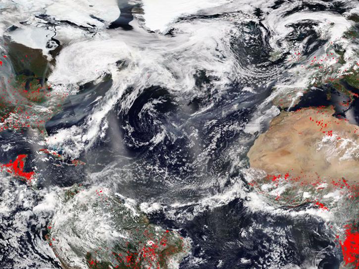
FIRMS was used to track the spread of smoke plumes during the Canadian wildland fires in June 2025.
Blog
June 17, 2025
A summary of datasets, products, and resources released by NASA’s Distributed Active Archive Centers (DAACs) in May 2025.
News
June 12, 2025
Image for June 8, 2025, from the GHRSST sea surface temperature analysis.
Worldview Image of the Week
June 9, 2025

Annual prescribed burns are crucial for improving and maintaining pasture and crop land health, and remote sensing data provides near real-time information on location and air quality.
News
June 6, 2025
The new VIIRS near real-time product is already in use, and users are encouraged to explore this replacement option for MODIS-based flood products.
Blog
June 2, 2025
A summary of datasets, products, and resources released by NASA’s Distributed Active Archive Centers (DAACs) in April 2025.
News
May 13, 2025

Researchers taught the SatVision Top-of-Atmosphere foundation model to recognize MODIS imagery features.
Feature Article
May 9, 2025
After 25 years, the Measurements Of Pollution In The Troposphere (MOPITT) instrument ceased observing carbon monoxide (CO) in the atmosphere on Feb. 1, 2025.
News
May 6, 2025
SHOWING 8 OF 450
Frequently Asked Questions
Earthdata Forum
Our online forum provides a space for users to browse thousands of FAQs about research needs, data, and data applications. You can also submit new questions for our experts to answer.
Submit Questions to Earthdata Forumand View Expert Responses