We are in the process of migrating all NASA Earth science data sites into Earthdata from now until end of 2026. Not all NASA Earth science data and resources will appear here until then. Thank you for your patience as we make this transition.
Read about the Web Unification Project
Webinars
Our online webinars, trainings, and workshops feature experts in various disciplines who share their knowledge in a particular subject area, from data in the cloud to specific data tools.
Featured Webinars

This NASA web-based tool enables near-real time monitoring of inland and coastal water quality across the U.S. and parts of Africa and South America.
July 1, 2026,2:00-3:00 p.m. EDT(1800-1900 UTC)

Learn how the Fire Information for Resource Management System (FIRMS) uses timely composite imagery to identify fire fronts, burned areas, and smoke.
July 16, 2026,2:00-3:30 p.m. EDT(1800-1930 UTC)

Diane Fritz, an associate scientist at NSIDC DAAC, demonstrates how to use the harmony-py Python library to customize data requests from the NASA Earthdata Cloud.
June 2, 2026,3:00-3:30 p.m. EDT(1900-1930 UTC)
Filters
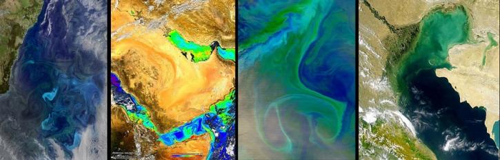
NASA's Ocean Biology Distributed Active Archive Center (OB.DAAC) manages, archives and distributes nearly 40 years of ocean color, sea surface temperature, and sea surface salinity data. Join us to learn more about NASA ocean color data, services and tools!
Feb. 6, 2019,2:00 p.m. EST(1900 UTC)

Advances in sensor technology, processing capabilities, and data availability are revolutionizing the radar remote sensing discipline. Join us to learn about new sensors and how NASA’s ASF DAAC is creating new tools and services to make Synthetic Aperture Radar (SAR) data more available.
Nov. 28, 2018,2:00 p.m. EST(1900 UTC)

Urbanization is an important driver of change across our home planet. Join us to learn about NASA SEDAC data products that provide estimates of global impervious cover and urban extent at a common 30m spatial resolution.
Nov. 24, 2018,2:00 p.m. EST(1900 UTC)

Join us to learn how to use Drive as a robust FTP alternative, and other services for browsing and retrieving physical oceanography data at NASA's Physical Oceanography Distributed Active Archive Center (PO.DAAC).
Oct. 24, 2018,2:00 p.m. EDT(1800 UTC)

Looking to learn more about Suomi NPP VIIRS global land data products available from NASA? Join us for an overview of the data products and live demos on how to access and work with the data using a variety of tools from the Land Processes DAAC.
Sept. 26, 2018,2:00 p.m. EDT(1800 UTC)

Join us to learn how to discover, subset, access and visualize both MODIS and VIIRS data products using a suite of user-friendly tools developed by NASA's ORNL DAAC.
Aug. 16, 2018,2:00 p.m. EDT(1800 UTC)

This webinar will compare sea surface salinity data collected by the Aquarius and SMAP missions. We will showcase data visualization and data access tools available through NASA's Physical Oceanography Distributed Active Archive Center.
Aug. 10, 2018,2:00 p.m. EDT(1800 UTC)

NASA’s Operation IceBridge airborne mission has flown over 700 flights through some of the most stunning regions of the Arctic and Antarctic. Join us to learn how to discover and access data that “bridges” the gap between the ICESat and ICESat-2 missions.
July 25, 2018,2:00 p.m. EDT(1800 UTC)
SHOWING 8 OF 205