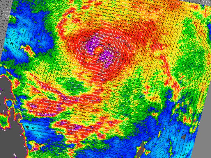
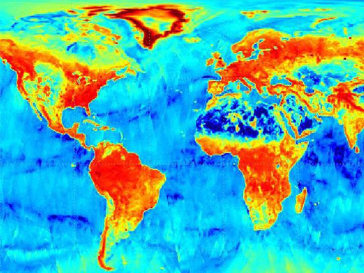
Earth Observation Data Basics

The life cycle of Earth observation data is rich and complex, with many points of entry along the pipeline. From collection to visualization, we dive deep into the basics to demystify the incredible data in our catalog.

Remote Sensing

Remote sensing is the acquiring of information from a distance. NASA observes Earth and other planetary bodies via remote instruments on space-based platforms (e.g., satellites or spacecraft) and on aircraft that detect and record reflected or emitted energy. Remote instruments, which provide a global perspective and a wealth of data about Earth systems, enable data-informed decision making based on the current and future state of our planet.

For more information, check out the Fundamentals of Remote Sensing training from the Applied Remote Sensing Training (ARSET) program.

Get Data

Explore the world’s largest repository of open-access Earth science data.

Remote Sensing Data Basics

An orbit is the curved path a satellite follows around the Earth due to gravitational force.
There are four types of resolution to consider for any dataset—radiometric, spatial, spectral, and temporal. Resolution plays a role in how data from a instrument can be used. Resolution can vary depending on the platform's orbit and instrument design.
Active instruments emit energy and collect data based on changes in the return signal.
Essential variables are known to be critical for observing and monitoring a given facet of the Earth system

Understanding Metadata

This interactive tool helps users navigate and understand essential metadata on our Earth science dataset landing pages. Through guided examples and hands-on exploration, learn critical context about our data to aid you in your own scientific discoveries.
Interactive

Parts of the Earthdata Dataset Landing Page

Explore
long name on dataset page
short name on dataset page
version on dataset page
DOI on dataset page
center/project on dataset page
cloud icon on dataset page
This is a screenshot of a dataset landing page showing the location of the alert icon.
copy URL/API on dataset page
data format on dataset page
dataset size on dataset page
spatial extent on dataset page
spatial resolution on dataset page
temporal extent on dataset page
user guide on dataset page
publications on dataset page
variables on dataset page
platforms on dataset page
instruments on dataset page
coordinate system on dataset page
granule spatial representation on dataset page
temporal resolution in dataset page
concept ID on dataset page
data state on dataset page
Number of files or granules
data processing level on dataset ppage
science keywords on dataset page
citation on dataset page
file naming convention on dataset page

Technology

Innovations in artificial intelligence, climate models, and cloud computing are improving the ways users work with Earth science data, especially massive datasets like those expected from NISAR. NASA leverages modern computing approaches to optimize the quality of data collected and the speed at which users are able to drill down to the details they need to support on-the-ground science.

Image

Cloud Computing

Nearly all of NASA’s Earth science data is accessible through Earthdata Cloud, making access, analysis, and visualization more efficient and cost effective. We offer resources including Python libraries, tutorials, and data recipes to help users optimize working with data in the cloud.

Image

Earth Observation Data and Artificial Intelligence

The application of artificial intelligence (AI) to Earth science data makes it possible to search through large amounts of data to find relationships.

Synthetic Aperture Radar

Synthetic aperture radar (SAR) is a type of remote sensing that produces fine-resolution data using a technology that, over time, can detect even minute changes on Earth’s surface.

SAR is one of the power technologies of remote sensing, and enables high resolution imagery to be created night or day, regardless of weather conditions.
The SAR Handbook was created in 2019 as a guide for forest monitoring and biomass estimation with synthetic aperture radar (SAR).
View a table of synthetic aperture radar (SAR) products and their processing levels available through NASA's Earth Science Data Systems (ESDS) Program.
General rules of thumb for interpreting synthetic aperture radar (SAR) imagery and resources for viewing SAR imagery.

Glossary of Terms

Reference the Earth Observation Data Basics Glossary to better understand terms related to the data provided by our program.

All
A B C D E F G H I J K L M N O P Q R S T U V W X Y Z
Earth Observing System Data and Information System (EOSDIS)

NASA's Earth Observing System Data and Information System (EOSDIS) is a key core capability in the Earth Science Data Systems (ESDS) Program. It provides end-to-end capabilities for managing NASA Earth science data from various sources—satellites, aircraft, field measurements, and various other programs. For the EOS satellite missions, EOSDIS provides capabilities for command and control, scheduling, data capture and initial (level 0) processing. These capabilities, constituting the EOSDIS Mission Operations, are managed by NASA's Earth Science Mission Operations (ESMO) Project. 

The remaining capabilities of EOSDIS constitute the EOSDIS Science Operations, which are managed by NASA's Earth Science Data and Information System (ESDIS) Project. These capabilities include: generation of higher level (levels 1-4) science data products for EOS missions; and archiving and distribution of data products from EOS and other satellite missions, as well as aircraft and field measurement campaigns. The EOSDIS science operations are performed within a distributed system which includes Science Investigator-led Processing Systems (SIPS) and distributed, discipline-specific, Earth science Distributed Active Archive Centers (DAACs). 

See: EOSDIS

Earth Science Data and Information System (ESDIS) Project

NASA's Earth Science Data and Information System (ESDIS) Project is a part of NASA's Earth Science Projects Division under the Flight Projects Directorate at NASA's Goddard Space Flight Center. ESDIS manages the science systems of NASA's Earth Observing System Data and Information System (EOSDIS). 

See Earth Observing System Data and Information System (EOSDIS)

See: ESDIS

Earth Science Data Type (ESDT)

Each type of science data collected by an instrument aboard a satellite supported by the ECS is given a data type name to be stored or archived in the ECS inventory (e.g., MISR001.) ESDTs also define the Services which can be applied to the data and the metadata associated with the data. In addition, ESDTs are defined for all data referenced in the ECS inventory and this includes some non-satellite data, and some non-instrument data (e.g., science software archive packages, algorithm packages, pge tar files, and delivered algorithm packages).

Earth Science Mission Operations (ESMO)

NASA's Earth Science Mission Operations (ESMO) Project is responsible for spacecraft maintenance and operations for Earth Science missions conducted by NASA's Earth Science Projects Division at NASA's Goddard Space Flight Center. ESMO plays a significant role during the mission life cycle; from the formulation and approval phases through the implementation and evaluation phases, and eventual deactivation. 

The Project's role is to ensure the health and safety of the missions it manages by fulfilling the primary operational requirements for each mission, and providing the scientific community with high-quality data products in a timely manner. It also serves as a focal point for the mission on-orbit operations and the definition of support services required.

See: ESMO

Engineering Data

Data which describe the physical condition and operation of the platform and instruments on the platform. Parameters might include temperatures at specific points, filter(s) in use, switch settings, memory data, etc.

EOS Data and Information System (EOSDIS) Core System (ECS)

The infrastructure which provides NASA's Earth Observing System (EOS) and other U.S. and international scientists a broad range of desktop services from NASA's discipline-specific Distributed Active Archive Centers (DAACs). The ECS infrastructure also supports exchange of data and research results within the science community, across multiple agencies and internationally. ECS is the evolutionary base for accelerating the pace of Earth science research.

See: EOSDIS

File Format

A term that is used for both "Data Format" and "Product Format" whose meaning should be understood by its context. 

See: Data Format

Flight Readiness Review (FRR)

FRRs evaluate the readiness of the program and its projects, ground systems, personnel, and procedures for a safe and successful launch and flight/mission.

Footprint

Geographic area covered by an instrument's observation and its derived products.

Formulation Agreement (FA)

The FA is prepared by the project to establish the technical and acquisition work that needs to be conducted during formulation and defines the schedule and funding requirements during Phase A and Phase B for that work.

Formulation Authorization Document (FAD)

The FAD is issued by the Mission Directorate Associate Administrator (MDAA) to authorize the formulation of a program whose goals will fulfill part of the Agency's Strategic Plan and Mission Directorate strategies and establish the expectations and constraints for activity in the Formulation Phase. In addition, a FAD or equivalent is used to authorize the formulation of a project. (See Appendix E.)

Forward Processing

A term used in data processing when the data is moving from one version to another version.

Global Attribute

An attribute that applies to either the entire file or the entire collection of files.

Global Imagery Browse Services (GIBS)

GIBS provides full resolution visual representations of NASA Earth science data in a free, open, and interoperable manner.

Granule
  1. The smallest aggregation of data which is independently managed (i. e. described, inventoried, retrievable). Granules may be managed as logical granules and/or physical granules. 

    See also: Scene 
     
  2. The smallest aggregation of independently managed (i.e., described, inventoried, retrievable) data at a DAAC. Some web applications and services provided by DAACs allow for the subsetting of granules. One granule usually comprises one file, more rarely multiple files. The latter is not optimal as it complicates data management by both the archive and users, and utilization by tools and services.
Granule Metadata

These are metadata elements that describe a single granule of a data product. Values of granule metadata apply to all of the data in that one granule. Typical metadata in this category describe spatial and temporal extent of the data as well as the quality and lineage of the data. 

See also: Granule.

Hierarchical Data Format (HDF)

The Hierarchical Data Format (HDF) is designed to facilitate managing and sharing scientific data. HDF includes two formats (HDF4 and HDF5), software for accessing data in HDF formats, and applications for working with HDF data. 

HDF is designed for efficient storage and access of high volume, complex data, and for mixing varieties of data types in a single container.

Ingestion

The ingestion function accepts data from different sources: ground segment reception, processing or data migration elements. The received data is quality checked and metadata including browse images are obtained from the data. The data and metadata form a data product. The product is consistently submitted to archiving and cataloguing.

Instrument Calibration

The instrument calibration function is the determination of parameters describing instrument characteristics. They are to be used by the instruments and ground processing to generate calibrated and comparable physical values. These parameters vary for different instruments and modes. And they may vary over time in the long run (degradation).

Inter-Project Agreement (IPA)

IPAs are agreements between ESDIS and projects not managed by ESDIS. Generally, the projects involved agree on an exchange of support services and data. From the interface control viewpoint, these agreements identify the need for an interface and the scope of the interface.

Interface Control Documents (ICD)

ICDs are used to record design agreements for the interfaces between participating organizations. ICDs provide a means to evaluate and control all mutually interdependent and/or interacting design parameters of the interface.

Interface Requirement Documents (IRD)

IRDs define the requirements for data exchanges across an interface between separately managed systems or subsystems. The requirements statements in IRDs are derived directly from project requirements documents.

Interoperability

The ability of different information technology systems and software applications to communicate, exchange data, and use the information that has been exchanged. 

In Earth observation it includes e.g. interoperable discovery and access, i.e. the capability of the user interface and administrative software of one instance of a catalogue service to interact with other instances of catalogue services. E.g. the capability of accessing granules in one data format with APIs or services of another API.

Inventory

The inventory function provides organization capabilities for archiving management. Data products can be grouped, searched and identified for retrieval, statistics and reorganization. Inventory is also referred to the list of available items stored and/or controlled in a storage warehouse system. 

In this latter case it is necessary to specify the kind of inventory, e.g. ICT Inventory for infrastructure inventory list.

Key Decision Point (KDP)

A key decision point (KDP) is the event at which the Decision Authority determines the readiness of a program/project to progress to the next phase of the life cycle (or to the next KDP).

Launch Readiness Review (LRR)

LRRs evaluate a program/project and its ground, hardware, and software systems for readiness for launch.

Launch Vehicle (LV)

LVs are rockets that send people and other payloads into space.

Long Term Preservation

The act of maintaining information in a correct and independently understandable form over the long term, i.e. a period of time long enough to be concerned with the impact which changing technologies, including support for media and data formats, and changing user communities will have on the information being held in a repository. 

See: Preservation.

Metadata

Data about data, contained in data sets, and which provides an understanding of the content and utility of the data set. Metadata may be used to select on data for a particular scientific investigation. 

Metadata is intended as information describing significant aspects of a resource (Earth Observation space data in this context). They are created for the purposes of data search, discovery and access management and may exist at various levels, typically from data collection through to the individual variables of each data file in a collection.

Mission Concept Review (MCR)

MCRs evaluate the feasibility of the proposed mission concept(s) and its fulfillment of the program's needs and objectives. MCRs also determine whether the maturity of the concept and associated planning are sufficient to begin Phase A.

Mission Definition Review (MDR)

MDRs evaluate the credibility and responsiveness of the proposed mission/system architecture to the program requirements and constraints, including available resources. MDRs also determine whether the maturity of the project's mission/system definition and associated plans are sufficient to begin Phase B.

Mission Readiness Review (MRR)

MRRs evaluate the readiness of the program and its projects, ground systems, personnel, and procedures for a safe and successful launch and flight/mission.

Mission Readiness Test Plan (MRTP)

The MRTP documents the strategy that will be used to verify and ensure that all system components working together meet design specifications and requirements for the mission.

Modeling

An investigative technique that uses a mathematical or physical representation of a system or theory that accounts for all or some of its known properties. Models are often used to test the effects of changes of system components on the overall performance of the system.

Mosaic

A composite of two or more images put together to create one image.

NASA-compliant General Application Platform (NGAP)

NGAP provides a NASA-compliant, secure, cloud-based Platform-as-a-Service (PaaS) and Infrastructure-as-a-Service (IaaS) for hosting Earth Observing System Data and Information System (EOSDIS) applications.

Definition from the Definition from the EOSDIS Engineering and Design (EED) contract team contract team

Near Real-Time (NRT) Data

NRT Data are those that are available for use with a specified (small and application dependent) latency, which is typically 3 hours for meteorological applications. See LANCE.

NetCDF-4/HDF5

NetCDF format that uses the HDF5 data storage model.

On-Demand Data Set

Collection of products that are generated in response to a user's request. Such products could either be pre-defined or not.

Operational Readiness Review (ORR)

ORRs evaluate the readiness of the program, including its projects, ground systems, personnel, procedures, and user documentation. ORRs also operate the flight system and associated ground systems in compliance with program requirements and constraints during the operations phase.

Operations Agreement (OA)

Operations Agreements are even lower level, more detailed interface documents that are created to help define the operations use of the interfaces, including such things as addresses, phone numbers, and names of responsible personnel. These documents are not intended for project-level development and control.

Parameter (or Variable)

A measurable or derived variable occurring in the physical or digital world. Variable and Parameter are used interchangeably. GCMD uses the term variable and NSIDC DAAC uses the term parameter.

Post-Flight Assessment Review (PFAR)

PFARs evaluate how well mission objectives were met during a human space flight mission. PFARs also evaluate the status of the flight and ground systems, including the identification of any anomalies and their resolution.

Post-Launch Assessment Review (PLAR)

PLARs evaluate the in-flight performance of the program and its projects. PLARs also determine the program's readiness to begin the operations phase of the life cycle and transfer responsibility to the operations organization.

Preliminary Design Review (PDR)

PDRs evaluate the completeness/consistency of the program's preliminary design, including its projects, in meeting all requirements with appropriate margins, acceptable risk, and within cost and schedule constraints, and to determine the program's readiness to proceed with the detailed design phase of the program.

Preservation

Preservation covers all processes and operations on individual or multi-mission data sets for ensuring the technical and intellectual survival of space data sets and their metadata through time. It grants dataset integrity, its discoverability and accessibility, and facilitates its use and reuse in the long term. 

Preservation is one of the tasks of data curation. Examples are data record improvement and consolidation.

Processing

The processing function generates higher-level products from lower level products and auxiliary products. The processing is performed by core algorithms supplemented by administrative functions (e.g. formatting). The algorithms are version controlled. Processing is able to produce the desired products systematically or on request.

Processing Levels

Raw Data 
The physical telemetry payload data as received from the satellite, i.e. a serial data stream without de-multiplexing. 

Level 0 
Reconstructed unprocessed data at full space-time resolution with all available supplemental information to be used in subsequent processing (e.g. ephemeris, health and safety) appended. 

Level 1A 
Reconstructed unprocessed data at full resolution, time-referenced, and annotated with ancillary information, including radiometric and geometric calibration coefficients and geo-referencing parameters (e.g. ephemeris) computed and appended but not applied to the Level 0 data. 

Level 1B 
Radiometrically corrected and calibrated data in physical units at full instrument resolution as acquired. Level 1C L1B data orthorectified, re-sampled to a specified grid 

Level 2 
Derived geophysical parameters (e.g. sea surface temperature, leaf area index) at the same resolution and location as Level 1 source data. 

Level 3 
Data or retrieved geophysical parameters which have been spatially and/or temporally re-sampled (i.e. derived from Level 1 or 2 products), usually with some completeness and consistency. Such re-sampling may include averaging and compositing. 

Level 4 
Model output or results from analyses of lower level data (i.e., variables that are not directly measured by the instruments, but are derived from these measurements; could be derived from multiple instrument measurements).

Product

1.
Electronic data package distributable to users; content is derived from instrument data via processing involving ancillary and auxiliary data. Products may comprise metadata and browse images. 

2.
A product may be part of a collection – a distinction useful for archiving and cataloging purposes. 

3.
The term product may be used to denote a product type, such as e.g. ENVISAT_ASAR_L1B_PRI data. 

4.
End users may distinguish between (input, "raw") data and products, i.e. the derived geophysical parameters.

Product Application

Useful references to published articles about the use of the data and user feedback received by the science and instrument teams about the products. Includes reports of any peculiarities or notable features observed in the products.

Join Our Community of NASA Data Users

While NASA data are openly available without restriction, an Earthdata Login is required to download data and to use some tools with full functionality.

Learn About the Benefits of Earthdata Login

Frequently Asked Questions

Earthdata Forum

Our online forum provides a space for users to browse thousands of FAQs about research needs, data, and data applications. You can also submit new questions for our experts to answer.

Submit Questions to Earthdata Forumand View Expert Responses

Earthdata
Forum