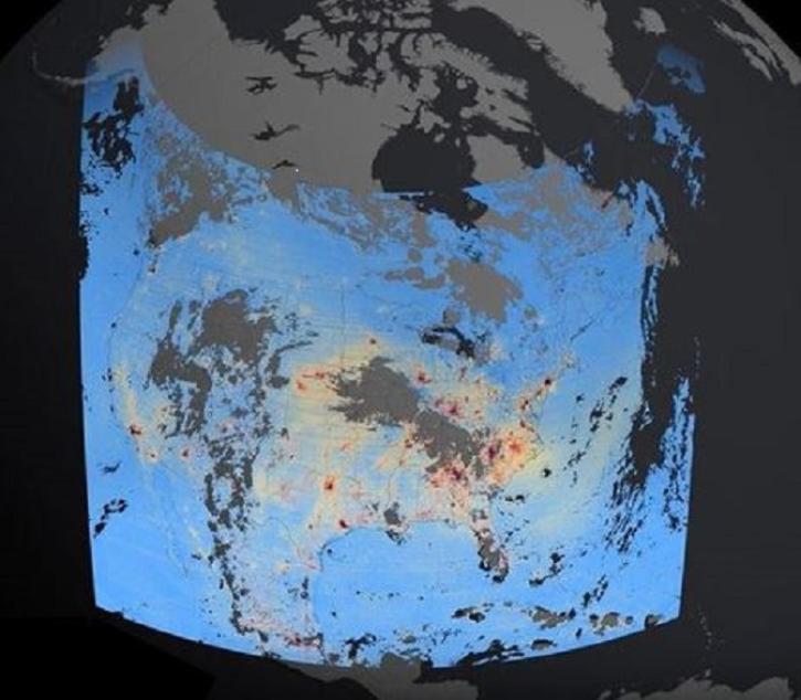
| Global Annual PM2.5 Grids from MODIS, MISR and SeaWiFS Aerosol Optical Depth (AOD) with GWR, 1998-2016 |
1.0 |
MODELS, Aqua, Terra, OrbView-2 |
Computer, MODIS, MISR, SeaWiFS |
1998-01-01 to 2016-12-31 |
N: 69.85
S: -54.85
E: 180
W: -180
|
0.1 Decimal Degrees x 0.1 Decimal Degrees |
PDF, PNG, WMS, GeoTIFF |
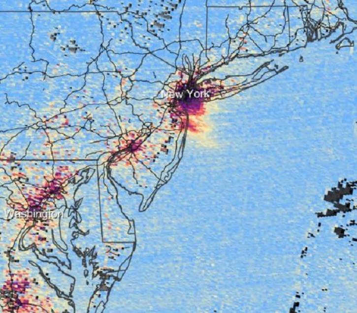
| Global Annual PM2.5 Grids from MODIS, MISR, SeaWiFS and VIIRS Aerosol Optical Depth (AOD), 1998-2022, V5.GL.04 |
5.04 |
MODELS, Aqua, Terra, SUOMI-NPP |
Computer, MODIS, MISR, VIIRS |
1998-01-01 to 2022-12-31 |
N: 69.85
S: -54.85
E: 180
W: -180
|
0.1 Decimal Degrees x 0.1 Decimal Degrees |
GeoTIFF, PDF, PNG, netCDF-4 |
| Global Fire Emissions Database, Version 4.1 (GFEDv4) |
4.1 |
MODELS, TRMM, Terra, ERS-1 |
Computer, VIIRS, MODIS, ATSR |
1995-06-01 to 2016-12-31 |
N: 90
S: -90
E: 180
W: -180
|
|
multiple |
| Global Fire Emissions Indicators, Country-Level Tabular Data: 1997-2015 |
1.0 |
Models |
Computer |
1997-01-01 to 2015-12-31 |
N: 90
S: -90
E: 180
W: -180
|
|
Excel |
| Global Fire Emissions Indicators, Grids: 1997-2015 |
1.0 |
Models |
Computer |
1997-01-01 to 2015-12-31 |
N: 90
S: -90
E: 180
W: -180
|
30 Decimal Degrees x 30 Decimal Degrees |
GeoTIFF, PDF, PNG, WMS |
| Global-Gridded Daily Methane Emissions from Inland Dam-Reservoir Systems |
1 |
Models |
Computer |
2002-01-01 to 2015-12-31 |
N: 90
S: -90
E: 180
W: -180
|
|
netCDF-4 classic |
| GPM Ground Validation Environment Canada (EC) Visibility Sensor FD12P C3VP V1 |
1 |
GROUND STATIONS |
FD12P WEATHER SENSOR |
2006-10-04 to 2007-03-31 |
N: 44.242
S: 44.222
E: -79.772
W: -79.791
|
|
ASCII |
| GSFC EPIC/MERRA2 L3 1x1deg Monthly Tropospheric Column Ozone V1 (TrCO3_Monthly_EPIC) at GES DISC |
1 |
MERRA-2 |
NOT APPLICABLE |
2015-01-01 to 2024-12-31 |
N: 90
S: -90
E: 180
W: -180
|
|
|
| GSFC OMI/MLS L3 1x1deg Monthly Tropospheric Column Ozone V2 (TrCO3_Monthly_OMIMLS) at GES DISC |
2 |
Aura |
OMI, MLS |
2004-10-01 to Present |
N: 90
S: -90
E: 180
W: -180
|
|
|
| GSFC OMPS/MERRA2 L3 1x1deg Monthly Tropospheric Column Ozone V1 (TrCO3_Monthly_OMPS) at GES DISC |
1 |
Suomi-NPP, MERRA-2 |
OMPS, NOT APPLICABLE |
2012-01-01 to Present |
N: 90
S: -90
E: 180
W: -180
|
|
|
| GSFC TOMS CCD L3 5x5deg Monthly Tropospheric Column Ozone V1 (TrCO3_Monthly_TOMS) at GES DISC |
1 |
Nimbus-7, EP-TOMS |
TOMS |
1979-01-01 to 2005-12-31 |
N: 90
S: -90
E: 180
W: -180
|
|
|
| HAQAST Sentinel-5P TROPOMI Nitrogen Dioxide (NO2) CONUS Annual Level 3 0.01 x 0.01 Degree Gridded Data V2.4 (HAQ_TROPOMI_NO2_CONUS_A_L3) at GES DISC |
2.4 |
Sentinel-5P |
TROPOMI |
2019-01-01 to Present |
N: 49.49
S: 24.5
E: -66.76
W: -124.75
|
1 Kilometers x 1 Kilometers |
|
| HAQAST Sentinel-5P TROPOMI Nitrogen Dioxide (NO2) CONUS Monthly Level 3 0.01 x 0.01 Degree Gridded Data V2.4 (HAQ_TROPOMI_NO2_CONUS_M_L3) at GES DISC |
2.4 |
Sentinel-5P |
TROPOMI |
2018-05-01 to Present |
N: 49.49
S: 24.5
E: -66.76
W: -124.75
|
1 Kilometers x 1 Kilometers |
|
| HAQAST Sentinel-5P TROPOMI Nitrogen Dioxide (NO2) CONUS Seasonal Level 3 0.01 x 0.01 Degree Gridded Data V2.4 (HAQ_TROPOMI_NO2_CONUS_S_L3) at GES DISC |
2.4 |
Sentinel-5P |
TROPOMI |
2018-06-01 to Present |
N: 49.49
S: 24.5
E: -66.76
W: -124.75
|
1 Kilometers x 1 Kilometers |
|
| HAQAST Sentinel-5P TROPOMI Nitrogen Dioxide (NO2) GLOBAL Annual Level 3 0.1 x 0.1 Degree Gridded Data Version 2.4 (HAQ_TROPOMI_NO2_GLOBAL_A_L3) at GES DISC |
2.4 |
Sentinel-5P |
TROPOMI |
2019-01-01 to Present |
N: 75
S: -60
E: 179.5
W: -179.5
|
10 Kilometers x 10 Kilometers |
|
| HAQAST Sentinel-5P TROPOMI Nitrogen Dioxide (NO2) GLOBAL Monthly Level 3 0.1 x 0.1 Degree Gridded Data Version 2.4 (HAQ_TROPOMI_NO2_GLOBAL_M_L3) at GES DISC |
2.4 |
Sentinel-5P |
TROPOMI |
2019-01-01 to Present |
N: 75
S: -60
E: 179.5
W: -179.5
|
10 Kilometers x 10 Kilometers |
|
| HAQES 3-Hourly Ensemble mean surface PM2.5 Black Carbon concentration at census level, North America V1 (HAQES_NA_PM25_BC_CENSUS) at GES DISC |
1 |
HAQES |
NOT APPLICABLE |
2022-11-01 to Present |
N: 53.5
S: 21
E: -58.5
W: -132
|
|
|
| HAQES 3-Hourly Ensemble mean surface PM2.5 Black Carbon concentration at county level, North America V1 (HAQES_NA_PM25_BC_COUNTY) at GES DISC |
1 |
HAQES |
NOT APPLICABLE |
2022-11-01 to Present |
N: 53.5
S: 21
E: -58.5
W: -132
|
|
|
| HAQES 3-Hourly Ensemble mean surface PM2.5 Black Carbon concentration, North America V1 (HAQES_NA_PM25_BC) at GES DISC |
1 |
HAQES |
NOT APPLICABLE |
2022-11-01 to Present |
N: 53.5
S: 21
E: -58.5
W: -132
|
12 Kilometers x 12 Kilometers |
|
| HAQES 3-Hourly Ensemble mean surface PM2.5 Organic Carbon concentration at census level, North America V1 (HAQES_NA_PM25_OC_CENSUS) at GES DISC |
1 |
HAQES |
NOT APPLICABLE |
2022-11-01 to Present |
N: 53.5
S: 21
E: -58.5
W: -132
|
|
|
| HAQES 3-Hourly Ensemble mean surface PM2.5 Organic Carbon concentration at county level, North America V1 (HAQES_NA_PM25_OC_COUNTY) at GES DISC |
1 |
HAQES |
NOT APPLICABLE |
2022-11-01 to Present |
N: 53.5
S: 21
E: -58.5
W: -132
|
|
|
| HAQES 3-Hourly Ensemble mean surface PM2.5 Organic Carbon concentration, North America V1 (HAQES_NA_PM25_OC) at GES DISC |
1 |
HAQES |
NOT APPLICABLE |
2022-11-01 to Present |
N: 53.5
S: 21
E: -58.5
W: -132
|
12 Kilometers x 12 Kilometers |
|
| HAQES 3-Hourly Ensemble mean surface total PM2.5 concentration at census level, North America V1 (HAQES_NA_PM25_TOT_CENSUS) at GES DISC |
1 |
HAQES |
NOT APPLICABLE |
2022-01-02 to Present |
N: 53.5
S: 21
E: -58.5
W: -132
|
|
|
| HAQES 3-Hourly Ensemble mean surface total PM2.5 concentration at county level, North America V1 (HAQES_NA_PM25_TOT_COUNTY) at GES DISC |
1 |
HAQES |
NOT APPLICABLE |
2022-01-02 to Present |
N: 53.5
S: 21
E: -58.5
W: -132
|
|
|
| HAQES 3-Hourly Ensemble mean surface total PM2.5 concentration, North America V1 (HAQES_NA_PM25_TOT) at GES DISC |
1 |
HAQES |
NOT APPLICABLE |
2022-01-02 to Present |
N: 53.5
S: 21
E: -58.5
W: -132
|
12 Kilometers x 12 Kilometers |
|