Earth Science Data Roundup: September 2025

A summary of datasets, products, and resources released by NASA’s Distributed Active Archive Centers (DAACs) in August 2025.

Atmospheric Science Data Center (ASDC)

ARCSIX LaRC G-III HALO Dataset Released

NASA’s ASDC released High Altitude Lidar Observatory (HALO) data collected onboard the LaRC G-III aircraft during the Arctic Radiation-Cloud-Aerosol-Surface Interaction EXperiment (ARCSIX) campaign. The HALO instrument provides nadir-viewing profiles of water vapor, methane columns, and profiles of aerosol and cloud optical properties. Data collection for this product is now complete.

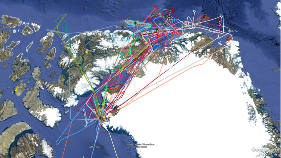
ARCSIX is a NASA field campaign aimed at quantifying the contributions of surface properties, clouds, aerosol particles, and precipitation to the Arctic summer surface radiation budget and sea ice melt. The campaign’s primary objective was to enhance long-term space-based monitoring and predictive capabilities of Arctic sea ice, cloud, and aerosols by validating and improving remote sensing algorithms and model parameterizations in the Arctic.

Access ARCSIX LaRC G-III HALO data and more information.

Image
Image Caption

The colored lines in this graphic show the paths of flights during the ARCSIX field campaign, which aimed to quantify the contributions of surface properties, clouds, aerosol particles, and precipitation to the Arctic summer surface radiation budget and sea ice melt. Credit: NASA

PACE-PAX ER-2 In-Situ Meteorology and Navigation Data Now Available

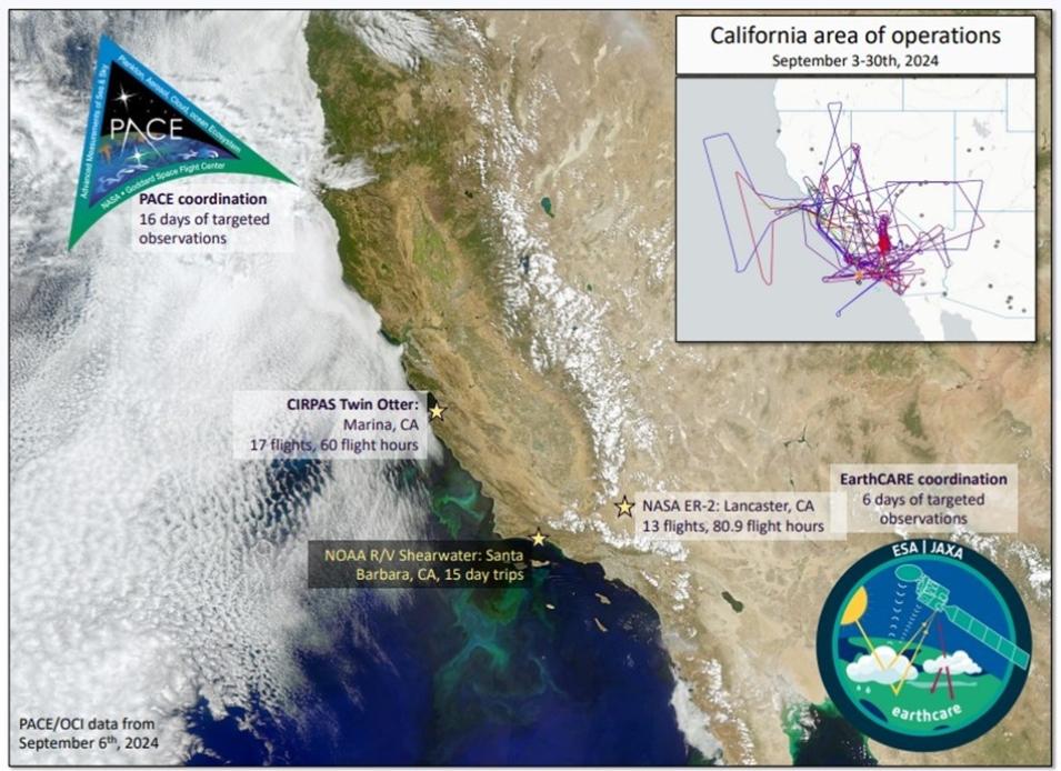
PACE-PAX ER-2 In-Situ Meteorology and Navigation Data, the in-situ meteorology and navigation data collected onboard the ER-2 aircraft during the Plankton, Aerosol, Cloud, ocean Ecosystem (PACE) Postlaunch Airborne eXperiment (PACE-PAX) campaign, is now available from ASDC.

The PACE-PAX campaign was conducted in September 2024 over southern and central California and nearby coastal regions to gather data for the validation and refinement of data products generated by the PACE satellite mission. Scheduled for roughly 9 months after the launch of PACE, 60 flight hours were planned for each of the 2 aircraft (NASA’s ER-2 high-altitude aircraft and the CIRPAS Twin Otter aircraft) used for in-situ sampling.

Flights were coordinated between the two aircraft, PACE satellite overpasses, and ground- and ocean-based observations. With a robust suite of in situ and remote sensing instruments and ground-based observations, PACE-PAX validated and refined PACE data products and identified any potential errors or biases in the measurements, which is essential for ensuring the accuracy and reliability of the PACE data products and maximizing the scientific value of the mission.

Access PACE-PAX ER-2 data and more information.

Image
Image Caption

This graphic shows the locations of the NASA ER-2 and CIRPAS Twin Otter aircraft flights over southern California and along the West Coast during the PACE-PAX campaign. The campaign was conducted in September 2024 over southern and central California and nearby coastal regions to gather data for the validation and refinement of data products generated by the PACE satellite mission. Credit: NASA

Global Hydrometeorology Resource Center Distributed Active Archive Center (GHRC DAAC)

ALOFT Campaign Datasets Released

NASA's GHRC DAAC released three datasets from the Airborne Lightning Observatory for FEGS and TGFs (ALOFT) campaign, a field campaign conducted by NASA and the University of Bergen. Its primary goals were to observe terrestrial gamma-ray flashes (TGFs) and gamma-ray glows in thunderstorms to collect Geostationary Lightning Mapper (GLM) validation from the Fly’s GLM Simulator (FEGS), and to validate observations from the Lightning Imaging Sensor (LIS) aboard the International Space Station. The datasets include:

  • The ALOFT Advanced Microwave Precipitation Radiometer (AMPR) Dataset, which consists of brightness temperature measurements collected by the Advanced Microwave Precipitation Radiometer (AMPR) aboard the NASA ER-2 high-altitude research aircraft. AMPR provides multi-frequency microwave imagery with high spatial and temporal resolution for deriving cloud, precipitation, water vapor, and surface properties. Data files are available from June 15, 2023, through July 31, 2023, in netCDF-4 format.
     
  • The ALOFT Cloud Radar System (CRS) Dataset, which consists of calibrated radar reflectivity, Doppler velocity, linear depolarization ratio, and normalized radar cross-section estimates collected by the Cloud Radar System (CRS) onboard the NASA ER-2 high-altitude research aircraft. Data files are available from June 15, 2023, through July 31, 2023, in HDF-5 format.
     
  • The ALOFT ER-2 X-Band Doppler Radar (EXRAD) Dataset, which consists of radar reflectivity and Doppler velocity estimates collected by the EXRAD onboard the NASA ER-2 high-altitude research aircraft. Data files are available from June 15, 2023, through July 31, 2023, in the HDF-5 format.

For data access and more information about each product, click on the dataset links above.

Goddard Earth Sciences Data and Information Services Center (GES DISC)

TROPICS Level 1C Data Products from CubeSats 1, 3, 5, and 6 Are Now Available

New Level 1C regularized-scan and limb-adjusted Brightness Temperature datasets from the Time-Resolved Observations of Precipitation structure and storm Intensity with a Constellation of Smallsats (TROPICS) mission are now available from NASA's GES DISC. These data products use inputs from TROPICS Level 1B products and provide improved imagery that does not contain the radiative brightening or darkening. The new products consist of data from three of the four constellation CubeSats launched in May 2023 and the Pathfinder CubeSat launched in August 2021.

The data products in this release include:

The purpose of these Level 1C data products is to provide users interested in imagery to have a product without the radiative limb brightening or darkening that is part of cross-track radiometers measuring a thicker amount of atmosphere at the edges of the scans. Another feature is regularizing the scan pattern to have less scan-to-scan variability. Each TROPICS netCDF file contains a granule of data with 81 spots and approximately 2,880 scans, where a granule is defined as an orbit's worth of data. 

For data access and more information about each product, click on the dataset links above.

Image
Image Caption

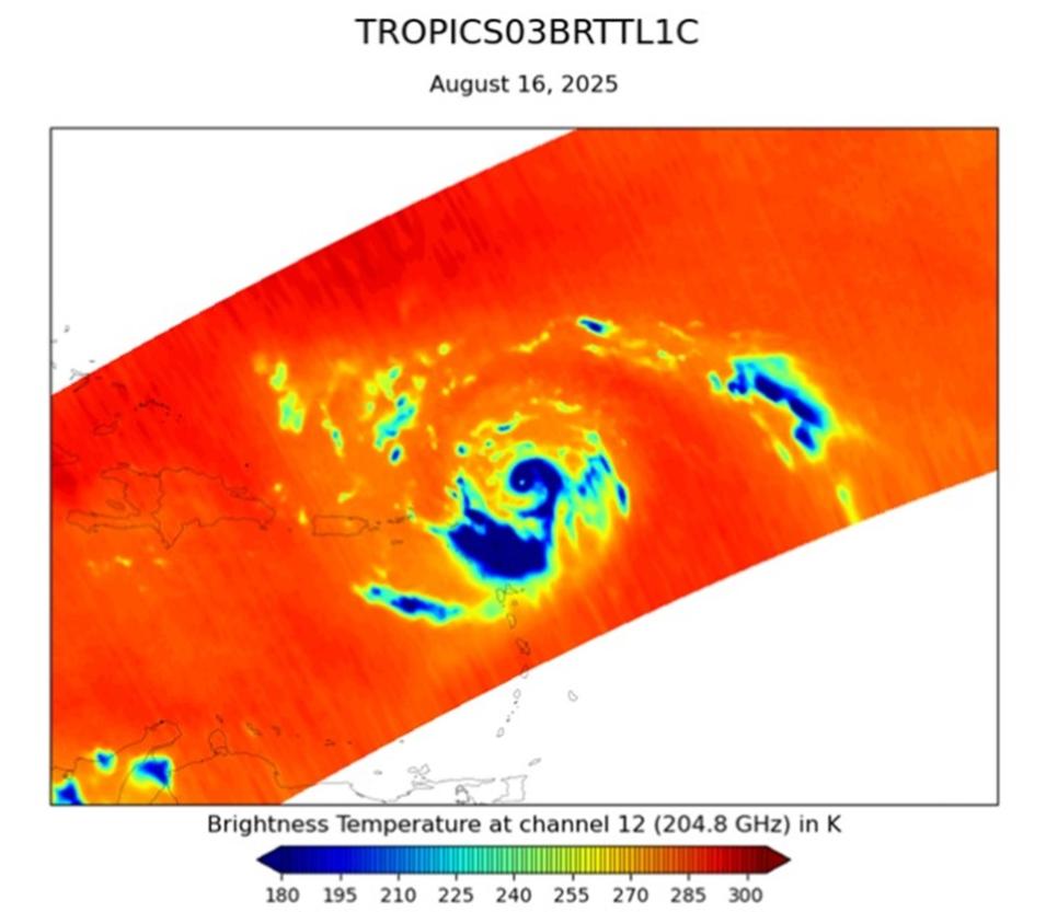
This graphic shows a swath of G-band TROPICS Level 1C Brightness Temperature data captured during Hurricane Erin, on August 16, 2025. Credit: GES DISC

OCO-2, OCO-3 Level 2 Forward-Stream Bias Corrected Data Products Released

NASA’s GES DISC released Level 2 forward-stream data products from the Orbiting Carbon Observatory-2 (OCO-2) and OCO-3 missions. These products include:

  • OCO-3 Level 2 bias-corrected XCO2 and other select fields from the full-physics retrieval aggregated as daily files, Forward Processing V11 (OCO3_L2_Fwd_FP)
  • OCO-3 Level 2 bias-corrected solar-induced fluorescence and other select fields from the IMAP-DOAS algorithm aggregated as daily files, Forward Processing V11 (OCO3_L2_Fwd_SIF)
  • OCO-2 Level 2 bias-corrected XCO2 and other select fields from the full-physics retrieval, Forward processing V11.2 (OCO2_L2_Fwd_FP)
  • OCO-2 Level 2 bias-corrected solar-induced fluorescence and other select fields from the IMAP-DOAS algorithm aggregated as daily files, Forward processing V11.2 (OCO2_L2_Fwd_SIF)

The Level 2 Fwd_FP files provide bias corrected, quality filtered values for the column-averaged dry-air mole fraction of carbon dioxide (XCO2), with the data aggregated into daily files, similar to the OCO Lite file data products. Similarly, the Level 2 Fwd_SIF files provide bias corrected and filtered values for solar induced fluorescence (SIF). 

These data products were developed for users who would like to use OCO-2/OCO-3 data within a week of the observations being taken, rather than waiting for the Lite files to be available (which is usually on the order of a few weeks). The Lite files, produced from the longer latency retrospective stream, will remain the recommended product for users who want the best quality long-term record from OCO-2 and OCO-3. GES DISC recommends that users switch to the Level 2 Lite files once they become available.

For data access and more information, click on the dataset links above.

OMPS NMEV and NPEV Level 1B Radiance Data Products Released

GES DISC released two Version 2 Level 1B data products from the Ozone Mapping and Profiler Suite (OMPS) Nadir Mapper (NM) and Nadir Profiler (NP) instruments aboard the Joint NASA-NOAA Suomi Polar-orbiting Partnership (Suomi NPP) satellite. The two data products are:

  • OMPS/NPP Level 1B NM Radiance EV Calibrated Geolocated Swath Orbital Version 2 (OMPS-NPP_NMEV_L1B): contains calibrated and geolocated radiances at 196 wavelengths between 300 and 380 nm. A typical data file contains a single orbit of data with 400 swaths along the daytime orbit track and 36 cross-track measurements. The swath width is 2800 km, and the pixel footprint size at nadir is 50 km x 50 km.
     
  • OMPS/NPP L1B NP Radiance EV Calibrated Geolocated Swath Orbital Version 2 (OMPS-NPP_NPEV_L1B): contains calibrated and geolocated radiances at 147 wavelengths between 250 and 310 nm. A typical data file contains a single orbit of data with 80 measurements along the daytime orbit track. The pixel footprint size is 250 km x 250 km.

OMPS nadir measurements begin on November 13, 2011, and contain gaps in the data until April 2, 2012, when regular continuous measurements began.

Access OMPS NMEV and NPEV Level 1B Radiance data and more information.

High-Resolution Gridded (HRG) Level 3 Aerosol Optical Depth (AOD) Datasets Now Available

High-Resolution Gridded (HRG) Level 3 Aerosol Optical Depth (AOD) datasets are now available for GES DISC. These data products are generated using operational Level 2 aerosol datasets from the Moderate Resolution Imaging Spectroradiometer (MODIS) and Visible Infrared Imaging Radiometer Suite (VIIRS) instruments. The product combines Aerosol Optical Depth (AOD) from Deep Blue (DB) and Dark Target (DT) algorithms at higher spatial resolution (0.1° x 0.1°) than the existing Level 3 operational gridded aerosol data from MODIS, which have been available since the beginning of the mission but at coarser spatial resolution. Further, the new HRG Level 3 datasets maintain the coverage and quality of Level 2 AOD data produced operationally and provide either the same or greater spatial coverage on daily and monthly scales.

Access HRG Level 3 AOD data and more information.

Image
Image Caption

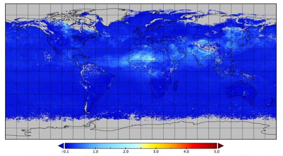
This graphic shows global High-Resolution Gridded (HRG) Level 3 Aerosol Optical Depth (AOD) data from the VIIRS instrument aboard the NOAA-20 satellite for the month of May 2025. Brighter colors indicate the presence of higher aerosol concentrations. Credit: GES DISC

Version 3 of Advanced Technology Microwave Sounder (ATMS) Level 1B Data Now Available

Version 3 of Advanced Technology Microwave Sounder (ATMS) Level 1B data are now available from GES DISC. The ATMS instrument is a cross-track microwave radiometer aboard both the Suomi NPP and NOAA-20 satellites.

The ATMS detector consists of 22 bands that provide information to compute total precipitable water, precipitation, information about cloud liquid water, sea-ice concentration, snow cover, and atmospheric humidity profiles. Data products are constructed on six-minute boundaries—each six-minute segment is called a granule—and there are 240 granules of data collected per day.

Access V3 ATMS Level 1B data and more information.

Sentinel-6A Michael Freilich Data Products Released

GES DISC released seven Sentinel-6A Michael Freilich Global Navigation Satellite System Radio Occultation (GNSS-RO) Level-1B  and Level-2 data products. They include:

  • Sentinel-6A EUMETSAT Radio Occultation Non-Time-Critical Level 1B V1 (S6A_RO_1B_BND__1)
  • Sentinel-6A GNSS Radio Occultation Level 1B Daily RINEX V1 (S6A_RO_1B_POD_RNX__1)
  • Sentinel-6A GNSS-POD Level 1B Daily RINEX V1 (S6A_GN_1B_RNXD_AX__1)
  • Sentinel-6 NASA/JPL GNSS-RO Near-Real-Time Level 1B V1 (S6A_RO_1B_NRT_NC__1)
  • Sentinel-6 NASA/JPL GNSS-RO Near-Real-Time Level 2 V1 (S6A_RO_2__NRT_NC__1)
  • Sentinel-6 JPL GNSS-RO Non-Time-Critical Level 1B V1 (S6A_RO_1B_NTC_NC__1)
  • Sentinel-6 NASA/JPL GNSS-RO Non-Time-Critical Level 2 V1 (S6A_RO_2__NTC_NC__1)

The Sentinel-6 Michael Freilich (S6MF) or Sentinel-6A radar altimeter satellite uses GNSS-RO, a remote sensing technique that uses radio signals broadcast from GNSS satellites, to infer temperature and water vapor profiles within Earth's atmosphere. As radio signals from GNSS transmitters travel along lines tangent to Earth's atmosphere to the Sentinel-6A receiver, they are refracted by the density gradient between space and Earth's atmosphere. This refraction appears as a bending of the signal that enables atmospheric properties to be inferred. The Level 1B data products include bending angles, while the Level 2 data products contain refractivity, temperature, and humidity profiles.

Access Sentinel-6A Michael Freilich data and more information.

Land Processes Distributed Active Archive Center (LP DAAC)

MODIS Version 6.1 OPeNDAP Access To Be Retired

NASA’s LP DAAC  announced that Access to MODIS Collection 6.1 datasets via legacy, on-premises Open-source Project for a Network Data Access Protocol (OPeNDAP) at will be retired in a phased approach. As new access links via NASA Earthdata Cloud OPeNDAP are being generated, corresponding legacy, on-premises OPeNDAP access will be disabled. A data alert will be posted as cloud OPeNDAP links are generated for each MODIS product suite. 

Users who currently access data through the legacy, on-premises OPeNDAP should consider enlisting one of the alternative methods available to assist them in updating their data access workflows and scripts. These include:

  • Earthdata Cloud OPeNDAP: Users can update their data access workflows and scripts to use the Cloud OPeNDAP endpoint. These links can be found in the granule metadata available through Earthdata Search.
  • Access data through AppEEARS: MODIS data will continue to be available through the Application for Extracting and Exploring Analysis Ready Samples (AppEEARS).
  • Access MODIS source data: MODIS source data can be accessed directly from NASA Earthdata Cloud. Detailed guides and tutorials can be found at the LP DAAC Data Resources GitHub.

Users with questions or comments are advised to contact LP DAAC User Services.

EMIT Level 3 Aggregated Mineral Spectral Abundance Version 2 Data Product Released

LP DAAC released NASA’s Earth Surface Mineral Dust Source Investigation (EMIT) Level 3 Aggregated Mineral Spectral Abundance and Uncertainty (EMITL3ASA) Version 2 data product at a 0.5 degree spatial resolution. This product provides aggregated mineral spectral abundance and uncertainty within regions between 52° N latitude and 52° S latitude for 10 minerals that are the focus of the EMIT mission. These data are produced from EMIT Level 2B Estimated Mineral Identification and Band Depth and Uncertainty (EMITL2BMIN) data using a new approach compared to its Version 1 predecessor. 

Users are encouraged to use Version 2 of this product which includes an added dependency on grainsize of sediment. EMITL3ASA Version 2 data are available as a static collection containing a single granule that uses EMITL2BMIN data from August 10, 2022, to January 20, 2024.

Access EMIT Level 3 Aggregated Mineral Spectral Abundance Version 2 data and more information.

National Snow and Ice Data Center Distributed Active Archive Center (NSIDC DAAC)

Select Version 7 ATLAS/ICESat-2 Along-Track Data Products Released

Version 7 of select Level 2A and Level 3A data products from the Advanced Topographic Laser Altimeter System (ATLAS) instrument aboard the Ice, Cloud, and Land Elevation Satellite-2 (ICESat-2) satellite are now available from NASA's NSIDC DAAC. The data products include:

  • Normalized Relative Backscatter Profiles (ATL04)
  • ATLAS/ICESat-2 L3A Land Ice Height (ATL06)
  • ATLAS/ICESat-2 L3A Land and Vegetation Height (ATL08)
  • ATLAS/ICESat-2 L3A Calibrated Backscatter Profiles and Atmospheric Layer Characteristics (ATL09)
  • ATLAS/ICESat-2 L3A Along Track Inland Surface Water Data (ATL13)

The ATL04 data contain atmospheric profiles of normalized relative backscatter. The other along-track datasets are comprised of surface-specific data products for land ice, vegetation and land, the atmosphere, and inland water.

Versions 6 of these data will be retired from NSIDC DAAC in six months. Upon retirement, data will no longer be accessible, but all related documentation will remain available on the dataset web page for future reference.

Access Version 7 ATLAS/ICESat-2 Along-Track data products and more information.

Image
Image Caption

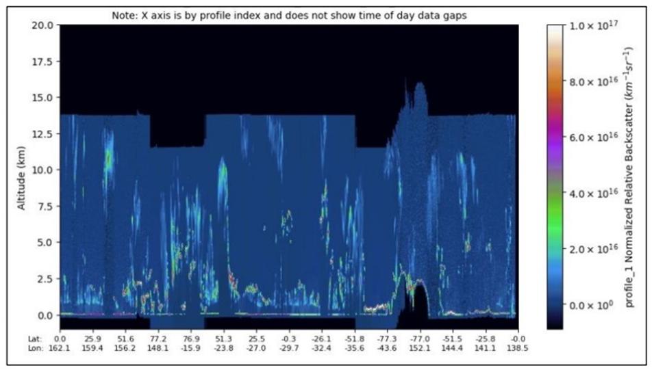
This browse image shows normalized relative backscatter in the atmosphere from the Normalized Relative Backscatter Profiles (ATL04) data product. The objective for the ICESat-2 atmospheric data is to produce a cloud/no cloud flag and to generalize the intensity of multiple scattering of the laser pulse due to clouds, fog, and blowing  snow. These profiles are then passed to and used by higher-level products to characterize the  atmosphere. Credit: NSIDC DAAC

SnowEx23 GIS References and Field Maps, Version 1 Dataset Now Available

The SnowEx23 GIS References and Field Maps, Version 1 dataset is now available from NSIDC DAAC. This dataset contains geolocation information for ground-based and airborne measurements collected in Alaska as part of the NASA SnowEx 2023 campaign. Temporal coverage spans from October 25, 2021, to November 30, 2023.

Access SnowEx23 GIS References and Field Maps, Version 1 data and more information.

SnowEx23 March 23 Intensive Observation Period (IOP) Snow Depth Profiles, Version 1 Dataset Released

NSIDC DAAC released the SnowEx23 Mar23 IOP Snow Depth Profiles, Version 1 dataset. This dataset contains snow depth profiles measured as part of the NASA SnowEx23 March 2023 Intensive Observation Period. Ground-based snow depth profile measurements were taken in the vicinity of 170 snow pits distributed across five study areas in Northern Alaska. Temporal coverage spans from March 7 to 16, 2023.

Access SnowEx23 March 23 IOP Snow Depth Profiles, Version 1 data and more information.

New NASA Earthdata Cloud Access Option for SMAP NRT Collection Now Available

NSIDC DAAC announced that the near real-time (NRT) Soil Moisture Active Passive (SMAP) Level 1B Radiometer Half-Orbit Time-Ordered Brightness Temperatures, Version 105, and the Near Real-time SMAP Level 2 Radiometer Half-Orbit 36 Kilometer EASE-Grid Soil Moisture, Version 107 datasets are now available in the NASA Earthdata Cloud.

These datasets will be available in the legacy HTTPS File System until October 28, 2025. Users who rely on this archive are encouraged to update direct download workflows and scripts to use the new Earthdata Cloud access URLs. The legacy HTTPS File System URL on the dataset landing page has been replaced with the Earthdata Cloud HTTPS File System URL. However, users can still find the legacy HTTPS URL in our Programmatic Data Access Guide.

The NSIDC DAAC User Services Office provides support for direct data download from the Earthdata Cloud HTTPS and basic access to our AWS Simple Storage Service (S3) buckets. For more details on these access options, see the Earthdata Cloud data Access Guide.

Learn more about the Earthdata Cloud access option for SMAP NRT data.

AMSR2 Daily Polar Gridded Sea Ice Concentrations and AMSR2 Daily Polar Gridded Brightness Temperature Datasets Updated

NSIDC DAAC announced that the Advanced Microwave Scanning Radiometer 2 (AMSR2) Daily Polar Gridded Sea Ice Concentrations and AMSR2 Daily Polar Gridded Brightness Temperatures datasets have been updated to Version 2. This update includes a format change from binary to netCDF, resolves the previous pole hole mask issue, and adds the 37H channel. Version 1 data products will be retired on September 29, 2025.

Access AMSR2 data and more information.

Near Real-Time AMSR2 EASE-Grid Daily Global Ice Concentration and Snow Extent, Version 1 Dataset Now Available

The Near Real-Time AMSR2 EASE-Grid Daily Global Ice Concentration and Snow Extent, Version 1 (NISE_A2) is now available from NSIDC DAAC. NISE_A2 is intended to be the replacement dataset for the Near Real-Time Special Sensor Microwave Imager (SSM/I)/Special Sensor Microwave Imager/Sounder (SSMIS) EASE-Grid Daily Global Ice Concentration and Snow Extent, Version 5 (NISE) data product. This new dataset contains the same fields as the NISE product, with AMSR2 input data replacing SSMIS. The data are provided in the 25-kilometer Northern Hemisphere and Southern Hemisphere Equal-Area Scalable Earth Grids (EASE-Grid).

Access NRT AMSR2 EASE-Grid Daily Global Ice Concentration and Snow Extent, Version 1 data and more information.

High Mountain Asia Supraglacial Lake Extents on Debris Covered Glaciers, 1988-2023, Version 1 Dataset Released

NSIDC DAAC released the High Mountain Asia Supraglacial Lake Extents on Debris Covered Glaciers, 1988-2023, Version 1 dataset. This dataset identifies the extent of supraglacial lakes (SGLs) from 1988 through 2023 on 769 of the largest debris-covered glaciers in the High Mountain Asia region. SGLs were generated via automated processing of 30-meter Landsat imagery and are provided at 1-year intervals from 2004 to 2023, at 2-year intervals from 1992 to 2003, and as a single 4-year interval from 1988 to 1991.

Access High Mountain Asia SGL Extents on Debris Covered Glaciers data and more information.

NSIDC DAAC to Retire Legacy Datasets

NSIDC DAAC announced it is retiring the following legacy datasets:

The NASA Earthdata Cloud is now the primary data archive for the data. Users accessing data through the legacy, on-premises archive, including through the HTTPS File System or through the Earthdata Search Stage for Delivery (ECHO Orders) option, should update their data access workflows and scripts to use the Earthdata Cloud archive. 

Access the NASA Earthdata Cloud NISE_A2 archive.

The NSIDC DAAC User Services Office provides support for direct data download from Earthdata Cloud HTTPS and access to our AWS Simple Storage Service (S3) buckets. View more details on these access options

Final IceBridge Datasets Added to NASA Earthdata Cloud

NSIDC DAAC has added four IceBridge datasets to NASA Earthdata Cloud, thereby completing the migration of all IceBridge collections to the cloud platform. The added datasets include:

  • IceBridge Digital Mapping Sensor (DMS) Level 3 Ames Stereo Pipeline Orthorectified Images, Version 1
  • IceBridge DMS Level 3 Ames Stereo Pipeline Photogrammetric DEM, Version 1
  • IceBridge Land, Vegetation, and Ice Sensor (LVIS) Level 0 Raw Ranges, Version 1
  • IceBridge DMS L1B Geolocated and Orthorectified Images, Version 1

While these datasets will continue to be available via their current URLs and workflows, these legacy access methods will be retired soon. Users are encouraged to update their direct download workflows, including any data download scripts, to use the new Earthdata Cloud HTTPS location. 

Access the IceBridge datasets and more information.
Image
Image Caption

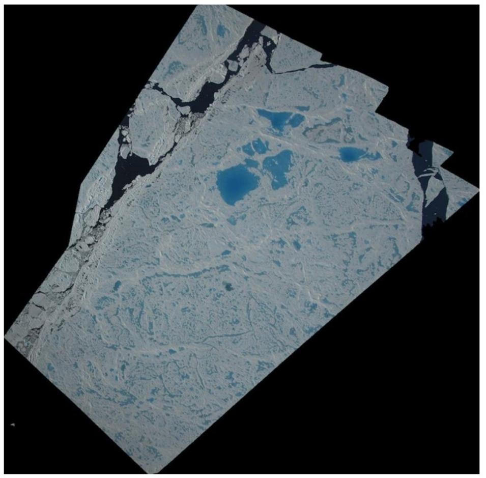
One of the IceBridge Digital Mapping Sensor (DMS) Level 3 Orthorectified Images created using the NASA Ames Stereo Pipeline, an open-source suite of automated tools designed for processing stereo images from satellites and robotic explorers, enabling the creation of 3D models and digital terrain maps. Credit: NSIDC DAAC

IceBridge UAF Level 2 HF and ARES Level 2 Bed Elevation and Ice Thickness Datasets Released

NSIDC DAAC released the IceBridge UAF Level 2 HF Bed Elevation and Ice Thickness, Version 1 and IceBridge ARES Level 2 Bed Elevation and Ice Thickness, Version 1 datasets. These datasets contain glacier surface elevation, bed elevation, and ice thickness measurements for Alaska and Northwestern Canada. Both datasets use the same glacier surface elevation derived from lidar but differ in the radar bed return data source.

Access both IceBridge datasets and more information.
AMSR-E/AMSR2 Unified L2B Half-Orbit 25 km EASE-Grid Surface Soil Moisture, Version 1 Dataset Updated

NSIDC DAAC announced that the Advanced Microwave Scanning Radiometer for EOS (AMSR-E)/AMSR2 Unified Level 2B Half-Orbit 25-kilometer EASE-Grid Surface Soil Moisture, Version 1 dataset has been updated. This update includes the addition of the AMSR-E derived data, with temporal coverage of the dataset now spanning June 2002 to the present (with a gap in data from October 2011 to July 2012, between the end of the AMSR-E mission and the beginning of AMSR2).

This Level 2B product contains surface soil moisture at 25-km resolution, estimated from AMSR-E and AMSR2 brightness temperature observations using two different approaches: the Normalized Polarization Difference (NPD) algorithm and the Single Channel Algorithm (SCA). Soil moisture estimates are derived from AMSR-E and AMSR2 data which have been spatially resampled by the Japan Aerospace Exploration Agency (JAXA) to intercalibrate, or “unify,” the two sensors.

Access the AMSR-E/AMSR2 Unified L2B Half-Orbit 25 km EASE-Grid Surface Soil Moisture, Version 1 dataset and more information.

ICESat-2 and CryoSat-2 Level 4 Monthly Arctic Snow Depth and Sea Ice Thickness, Version 1 Dataset Now Available

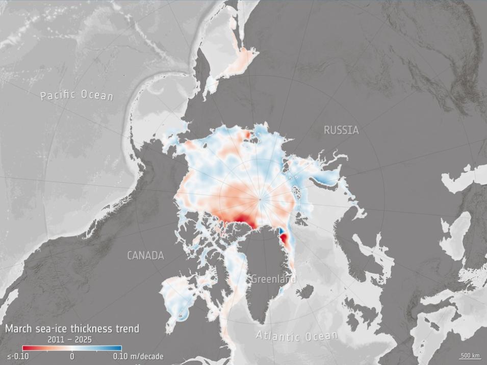
The ICESat-2 and CryoSat-2 Level 4 Monthly Arctic Snow Depth and Sea Ice Thickness, Version 1 Dataset is now available from NSIDC DAAC. This dataset contains monthly estimates of Arctic sea ice, snow depth, and ice thickness using combined ICESat-2 and CryoSat-2 freeboard measurements.

Access the ICESat-2 and CryoSat-2 Level 4 Monthly Arctic Snow Depth and Sea Ice Thickness, Version 1 dataset and more information.

Image
Image Caption

The graphic shows trends in sea ice thickness for the month of March during the years 2011 to 2025. The data used to generate the visualization were captured by the European Space Agency’s CryoSat-2 satellite. Red areas indicate a deceasing trend in sea ice thickness, while blue indicates increases. Credit: ESA

SSMIS Processing To Continue through September 2026

NSIDC DAAC announced that the U.S. Department of Defense (DoD) will continue the processing and delivery of data from the Special Sensor Microwave Imager/Sounder (SSMIS) instrument through the retirement of the DMSP mission, which is expected in September 2026. For further details, see the Status Update on DMSP Data Products

As a result, the following NSIDC DAAC datasets will continue to update:

  • Bootstrap Sea Ice Concentrations from Nimbus-7 SMMR and DMSP SSM/I (NSIDC-0079)
  • DMSP SSM/I Daily Polar Gridded Brightness Temperatures (NSIDC-0001)
  • Near-Real-Time DMSP SSM/I-SSMIS Daily Polar Gridded Brightness Temperatures (NSIDC-0080)
  • Near-Real-Time DMSP SSMIS Daily Polar Gridded Sea Ice Concentrations (NSIDC-0081)
  • Near-Real-Time SSM/I-SSMIS EASE-Grid Daily Global Ice Concentration and Snow Extent (NISE)
  • Sea Ice Concentrations from Nimbus-7 SMMR and DMSP SSM/I-SSMIS Passive Microwave Data (NSIDC-0051)

In addition, the Calibrated Enhanced-Resolution Passive Microwave Daily EASE-Grid 2.0 Brightness Temperature ESDR (NSIDC-0630) dataset will continue to provide SSMIS data, along with AMSR2 data.

Users should note that increased gaps in the DMSP SSMIS data, which began in late spring of 2025 as the DoD deprioritized the processing of SSMIS data, will remain possible through the end of the mission. Further, sensor failures may occur before the end of the mission occurs. Therefore, NSIDC DAAC recommends users relying on these SSMIS-based datasets begin evaluating the available AMSR2 alternatives:

  • AMSR2 Daily Polar Gridded Brightness Temperatures, Version 1 (NSIDC-0802)
  • AMSR2 Daily Polar Gridded Sea Ice Concentrations, Version 1 (NSIDC-0803)
  • Near-Real-Time AMSR2 EASE-Grid Daily Global Ice Concentration and Snow Extent, Version 1 (NISE_A2)

Note: Version 1 of the NSIDC-0802 and NSIDC-0803 datasets is in binary format, with Version 2 in netCDF format available in mid-August 2025.

Learn more about SSMIS data and processing.

Oak Ridge National Laboratory Distributed Active Archive Center (ORNL DAAC)

MASTER: Westcoast-Heartland Hyperspectral Microwave Sensor Intensive Experiment, Spring 2024 Dataset Released

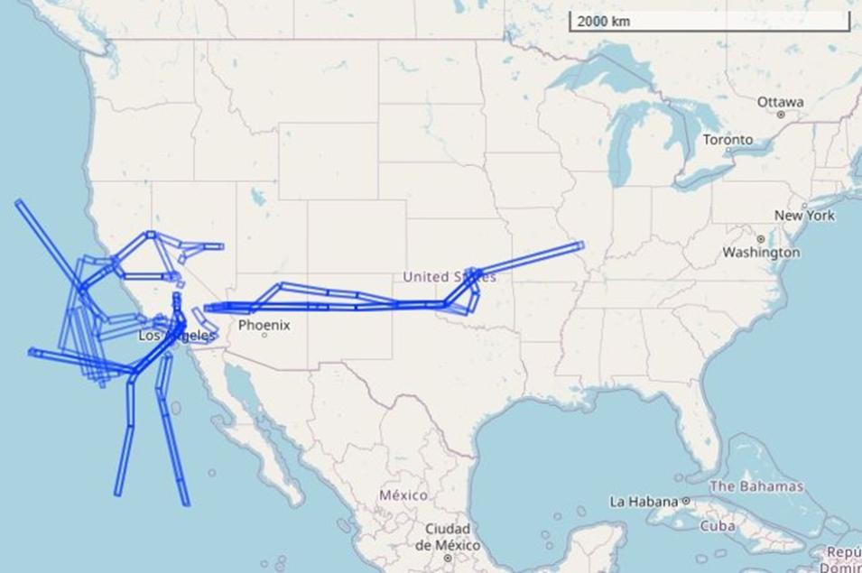
NASA's ORNL DAAC released the Westcoast-Heartland Hyperspectral Microwave Sensor Intensive Experiment, Spring 2024 Dataset from the MODIS/ASTER Airborne Simulator (MASTER) instrument. This dataset includes Level 1B and Level 2 data products collected as part of the Westcoast & Heartland Hyperspectral Microwave Sensor Intensive Experiment (WH2yMSIE) airborne campaign, which consisted of 10 NASA ER-2 aircraft flights across the central U.S. from Arkansas to California, and along the West Coast and eastern Pacific Ocean, from October 18 to November 13, 2024.

Data products include Level 1B georeferenced multispectral imagery of calibrated radiance in 50 bands covering wavelengths of 0.460 to 12.879 micrometers at approximately 50-meter spatial resolution. Derived Level 2 data products are emissivity in five bands in thermal infrared range (8.58 to 12.13 micrometers) and land surface temperature. The Level 1B file format is HDF-4, and the Level 2 products are provided in HDF-5 and KMZ formats. In addition, the dataset includes the flight path, spectral band information, instrument configuration, ancillary notes, and summary information for each flight, and browse images derived from each Level 1B data file.

Access Westcoast-Heartland Hyperspectral Microwave Sensor Intensive Experiment, Spring 2024 data and more information.

Image
Image Caption

This graphic shows flight tracks over U.S. and eastern Pacific Ocean (represented as rectangular polygons) during the MASTER campaign. Flights took place between October 18 and November 13, 2024. Basemap: © OpenStreetMap contributors. Credit: ORNL DAAC

AVIRIS-Classic: Level 1B Calibrated Radiance, Facility Instrument Collection, Version 11 Dataset Now Available

The AVIRIS-Classic: Level 1B Calibrated Radiance, Facility Instrument Collection, Version 11 Dataset is now available from ORNL DAAC. This dataset contains Level 1B orthocorrected, scaled radiance image files as well as files of observational geometry and illumination parameters and supporting sensor band information from the Airborne Visible/Infrared Imaging Spectrometer (AVIRIS-Classic) instrument.

AVIRIS-Classic measures reflected radiance in 224 contiguous bands at approximately 10-nanometer (nm) intervals in the Visible to Shortwave Infrared (VSWIR) spectral range from 400-2500 nm. The instrument is flown on a variety of aircraft platforms including the Twin Otter, NASA's WB-57, and NASA's high altitude ER-2. Multiple file types are included for each flight line. The primary data files include orthocorrected calibrated radiance image files, geometric lookup table, and orthocorrected observation geometry and illumination files. Also included are unprojected files of input geometry and parameters relating to the geometry of observation and illumination. Additional files provide information on spectral and radiometric calibration, spatial resolution, aircraft and sensor position, deployment notes, and data processing. Quicklook images and polygon outlines of imagery footprints are provided for each flight line. The primary AVIRIS-Classic Level 1B data are provided in ENVI binary format, which includes a flat binary file accompanied by a header file holding metadata in text format. The ancillary files include JPEG images, maps in Keyhole Markup Language (KML), and calibration files in binary and text formats. This archive currently includes data from 2004, and 2006 to 2025. Additional Level 1B data will be added as they become available. 

Access the AVIRIS-Classic: Level 1B Calibrated Radiance, Facility Instrument Collection, Version 11 dataset and more information.

AVIRIS-Classic Level 2 Calibrated Reflectance, Facility Instrument Collection, Version 1 Dataset Released

ORNL DAAC released the Level 2 Calibrated Reflectance, Facility Instrument Collection, Version 1 dataset, which offers Level 2 orthocorrected reflectance data from the AVIRIS-Classic instrument. The Level 2 data are provided in ENVI format, which includes a flat binary file accompanied by a header (.hdr) file holding metadata in text format. This archive currently includes data from 2008 to 2025. Additional AVIRIS-Classic facility instrument Level 2 data will be added as they become available. AVIRIS-Classic supports NASA Science and applications in many areas including plant composition and function, geology and soils, greenhouse gas mapping, and calibration of orbital platforms.

Access the Level 2 Calibrated Reflectance, Facility Instrument Collection, Version 1 dataset and more information.

Image
Image Caption

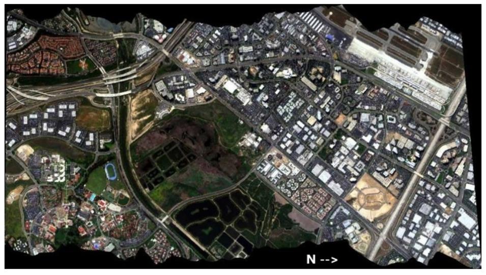
A Red-Green-Blue composite image from AVIRIS-Classic flight on May 10, 2006, over Irvine, CA. The main objective of the AVIRIS project is to identify, measure, and monitor constituents of the Earth's surface and atmosphere based on molecular absorption and particle scattering signatures. Research with AVIRIS data is predominantly focused on understanding processes related to the global environment and climate. Credit: ORNL DAAC

Physical Oceanography Distributed Active Archive Center (PO.DAAC)

GHRSST Level 4 Sea Surface Temperature SPoRT Dataset Now Available

The Group for High Resolution Sea Surface Temperature (GHRSST) Level 4 SPoRT Global Foundation Sea Surface Temperature Analysis (v1.0) dataset is now available from NASA's PO.DAAC. This dataset provides continuous, high-resolution, composited near-global sea surface temperature (SST) fields twice daily at 2 km resolution for regional weather, maritime, and coastal applications. 

The NASA Short-term Prediction Research and Transition (SPoRT) SST analysis composites seven-days of Visible Infrared Imaging Radiometer Suite (VIIRS) and Advanced Very High Resolution Radiometer (AVHRR) satellite Level 2 SST data, with additional data from Operational Sea Surface Temperature and Sea Ice Analysis (OSTIA) and Geo-Polar Blended Level 4 SST products into a single analysis. The data are packaged according to the GHRSST Data Specification version 2 in netCDF4 format.

Access GHRSST Level 4 Sea Surface Temperature SPoRT data and more information.

Details

Last Updated

Oct. 8, 2025

Published

Sept. 4, 2025

Data Center/Project

Atmospheric Science Data Center (ASDC)
Goddard Earth Sciences Data and Information Services Center (GES DISC)
Global Hydrometeorology Resource Center DAAC (GHRC DAAC)
Land Processes DAAC (LP DAAC)
National Snow and Ice Data Center DAAC (NSIDC DAAC)
Oak Ridge National Laboratory DAAC (ORNL DAAC)
Physical Oceanography DAAC (PO.DAAC)